

From EVs and batteries to autonomous vehicles and urban transport, we cover what actually matters. Delivered to your inbox weekly.
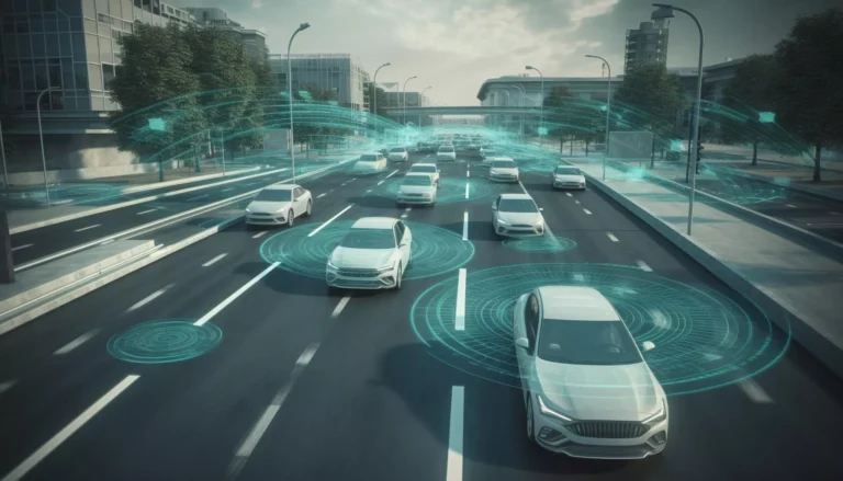
Across Europe, streets are lined with traffic cameras, but most just sit there, watching. They capture hours of footage but offer little help to the people managing roads and traffic.
That’s the gap Greenroads.ai is closing.
The Maltese startup turns existing traffic cameras, and even drones, into smart sensors. Instead of adding new hardware or doing slow, manual traffic counts, cities can use Greenroads’ AI platform to turn video into real-time traffic data. It shows how cars, bikes, scooters, and people move – and it does it all while staying fully GDPR-compliant.
Greenroads.ai was built on a simple but bold idea:
Why install new sensors when cities already have cameras everywhere?
Founded in 2019 in Mgarr, Malta, the company began inside the EU’s Climate-KIC incubator, which supports startups focused on climate and transport. CEO Claire Ciancio and her team believed real transport change starts with knowing what’s happening on the ground. And most cities already had the tools, they just weren’t using them well.
So Greenroads found a better way They are on a mission to turn existing traffic cameras, and drones, into AI-powered mobility sensors.
From the start, two values guide their work:
That vision has grown into a full analytics platform for cities, planners, and engineers. It helps them understand how roads are used – without new hardware.
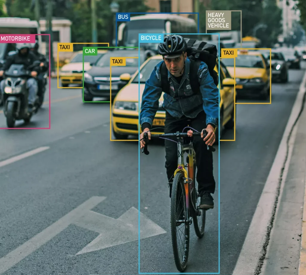
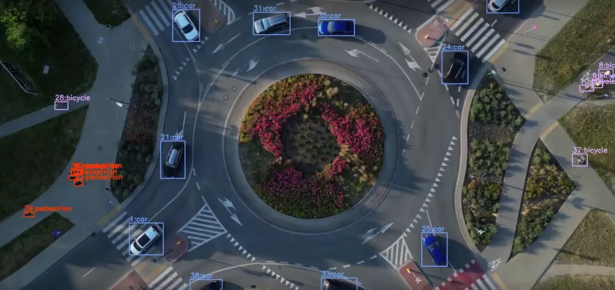
At the heart of Greenroads.ai is GreenFlow, a cloud-based tool that turns any traffic camera into a real-time traffic sensor.
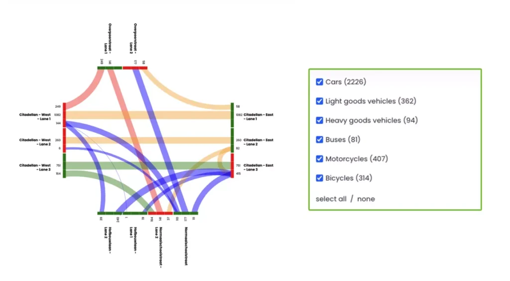
It works with both fixed roadside cameras and aerial drones. Once the video feed comes in, GreenFlow uses advanced AI to spot and track every road user, including cars, buses, trucks, bikes, pedestrians, and even scooters.
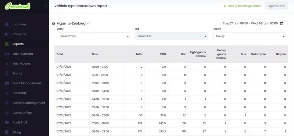
From that video, GreenFlow creates a live stream of useful data:
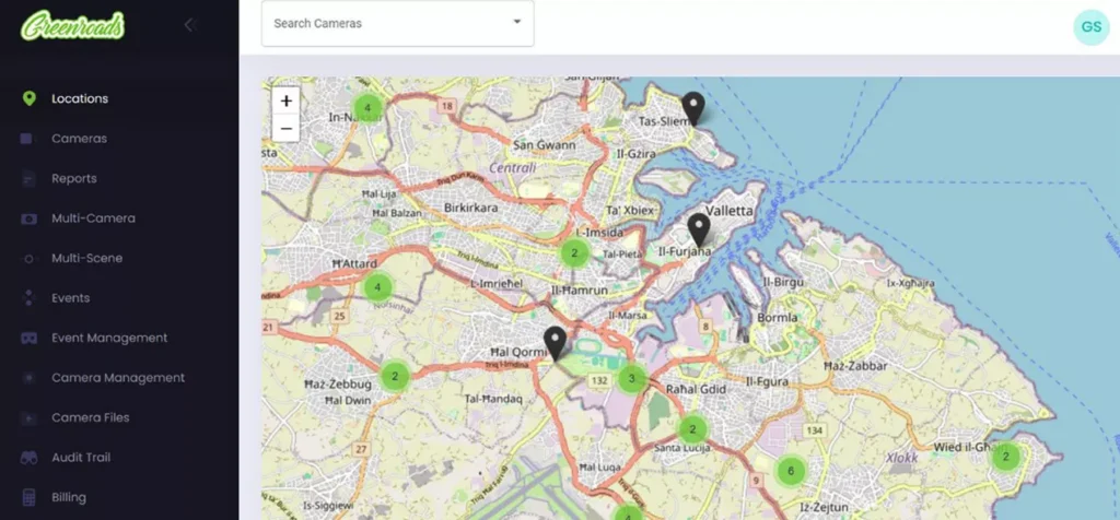
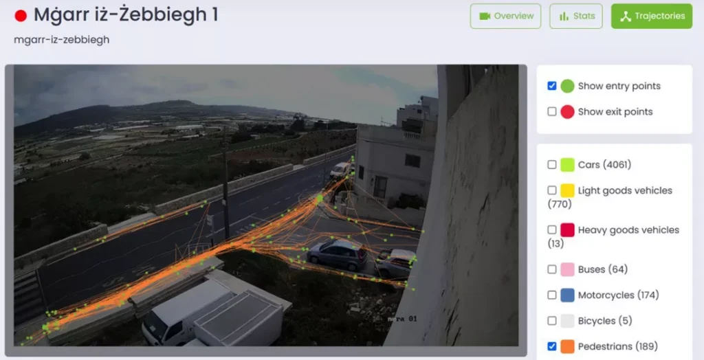
All of this shows up in a simple web dashboard.
GreenFlow also comes with full API access, so cities can link it to traffic control systems, mapping tools, or other apps. They can run it live, or upload recorded video to study past events or test new ideas, like changes to an intersection or a new bike lane.
Also, privacy is built in from the start.
GreenFlow is 100% GDPR-compliant. It doesn’t store license plates, faces, or anything that could identify a person. That makes it one of the few AI traffic tools ready for wide use in Europe’s public sector.
And what they deliver is a plug-and-play system that gives cities something they’ve long needed – a clear, real-time view of how their streets are being used without new equipment and without risking privacy.
At the center of the platform is a cloud-based AI engine. It uses custom deep-learning models to detect and track every kind of road user in every frame of video. The system then turns those movements into useful tools like heatmaps, turning ratios, and conflict zone maps.
With help from Microsoft for Startups, Greenroads needs no on-site servers or extra equipment. Cities don’t have to worry about setup, since the entire process happens remotely and securely.
Another major strength is using drones instead of lots of cameras.
A single drone flight can capture video of a full street, roundabout, or corridor. That video is sent to Greenroads’ AI system, just like footage from a fixed camera. Drones help cities cut costs and get results fast, especially for short-term studies or before-and-after projects.
Greenroads supports two main modes:
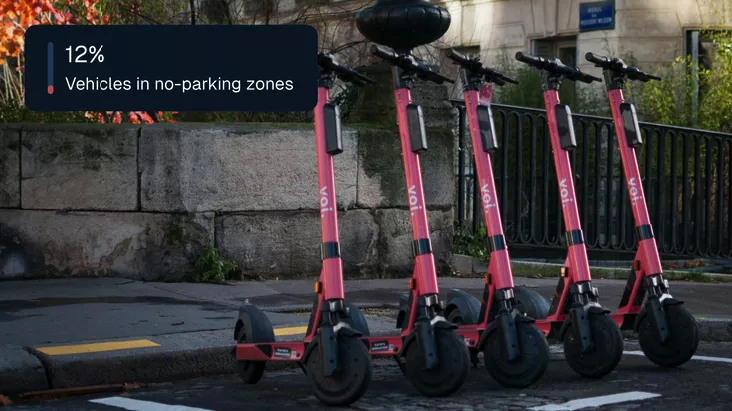
The system also can detect cyclists, pedestrians, scooters, buses, and trucks, giving planners a clear picture of how streets are shared.
And as always, it keeps privacy front and center. No faces, no license plates, no personal data.
Greenroads.ai was built for one group – the people responsible for how cities move.
Its users are:
Because the platform works with both fixed cameras and drones, it’s useful for long-term monitoring and short-term studies. Cities can use it to count pedestrians, analyze e-scooter use, or study how traffic signals affect vehicle movement during busy hours.
One key strength is that Greenroads tracks all types of road users. That makes it perfect for cities focused on safe streets, bike access, or Vision Zero goals. From spotting risky crossings to measuring how people really use public space, the platform gives fast, privacy-safe insights so planners and policy makers can act with confidence.
In Ghent, Belgium, the city flew drones over a busy roundabout and ran the video through GreenFlow. From just one hour of footage, the platform found 27 conflict points between cars, bikes, and people on foot, helping officials adjust signal timing to improve safety.
In Malta, Greenroads set up 16 fixed cameras along major roads. Planners used the data to track traffic, watch pedestrian movements, and study how people responded to new crosswalks. One pilot showed that unsafe crossings dropped soon after the new crossings were added.
Other real-world uses include:
Because Greenroads works with existing traffic cameras, or quick drone flights, cities can gather traffic data without major setup costs or long waits.
Instead of selling hardware, Greenroads offers traffic insights as a subscription software service.
Cities, transport agencies, and consultants pay to access the GreenFlow platform through the cloud. The subscription covers:
New users can try the system through a free trial, testing it with their own cameras or drone footage before making a full commitment.
While prices aren’t listed online, the value is easy to see:
Greenroads also earns revenue from city contracts and EU-funded projects, including programs like EIT Urban Mobility and Horizon Europe. These allow smaller cities or pilot projects to use the platform without high upfront costs.
There’s no public price list, but the return on investment is strong.
Greenroads.ai works in a busy space. Many companies today offer traffic analytics and video-based tools, but Greenroads takes a different approach.
Big names like Miovision, Genetec (BriefCam), and Iteris focus on large, expensive systems. These often need special hardware and are designed mostly for vehicle traffic in North American cities.
Greenroads is different. It’s lighter, simpler, and designed for Europe, especially its smaller cities.
Here’s what sets it apart:
Many older systems focus on enforcement or lock cities into one vendor. Greenroads, instead, aims to make smart mobility tools more accessible, especially for cities with small teams or limited budgets.
Greenroads.ai isn’t mindlessly chasing big venture capital. It’s a civic-focused company, led by people who care deeply about cities, data, and smarter mobility.
The company was founded in 2019 by Claire Ciancio, after she completed the EIT Climate-KIC incubator, a European program that supports climate-focused startups. Claire saw a major problem – cities have cameras everywhere, but no tools to understand what’s happening on their roads.
She teamed up with Johan Zammit, Andre Xuereb, and Adrian Muscat – experts in AI, urban systems, and digital infrastructure. Together, they built Greenroads to help public authorities make better decisions using data they already had.
From the start, Greenroads has focused on public benefit over private profit. That’s why it didn’t raise venture capital. Instead, it’s been funded by:
This approach lets Greenroads stay focused on the real needs of cities, rather than pleasing investors.
Greenroads.ai has already built the core technology, and now it’s focused on helping more cities use it.
The company’s next steps are all about growth, access, and smarter tools:
The bigger vision is to turn every camera, from traffic poles to drones, into a real-time mobility sensor that helps make cities cleaner, safer, and easier to navigate.
If Greenroads succeeds, it will change how transport planning works across Europe.
If cities want to cut emissions, keep people safe, and use public space better, they need one thing first, and that’s clear visibility.
Not just once-a-year traffic counts, but real-time, everyday insights into how streets are used by cars, bikes, and people on foot. That means spotting the cyclist pushed off a roundabout. The child crossing mid-block. The traffic that builds up right before school ends. And doing all of it without tracking license plates or faces.
That’s the role Greenroads is playing.